
Faroe Islands > Things to do in Faroe Islands > Gjógv
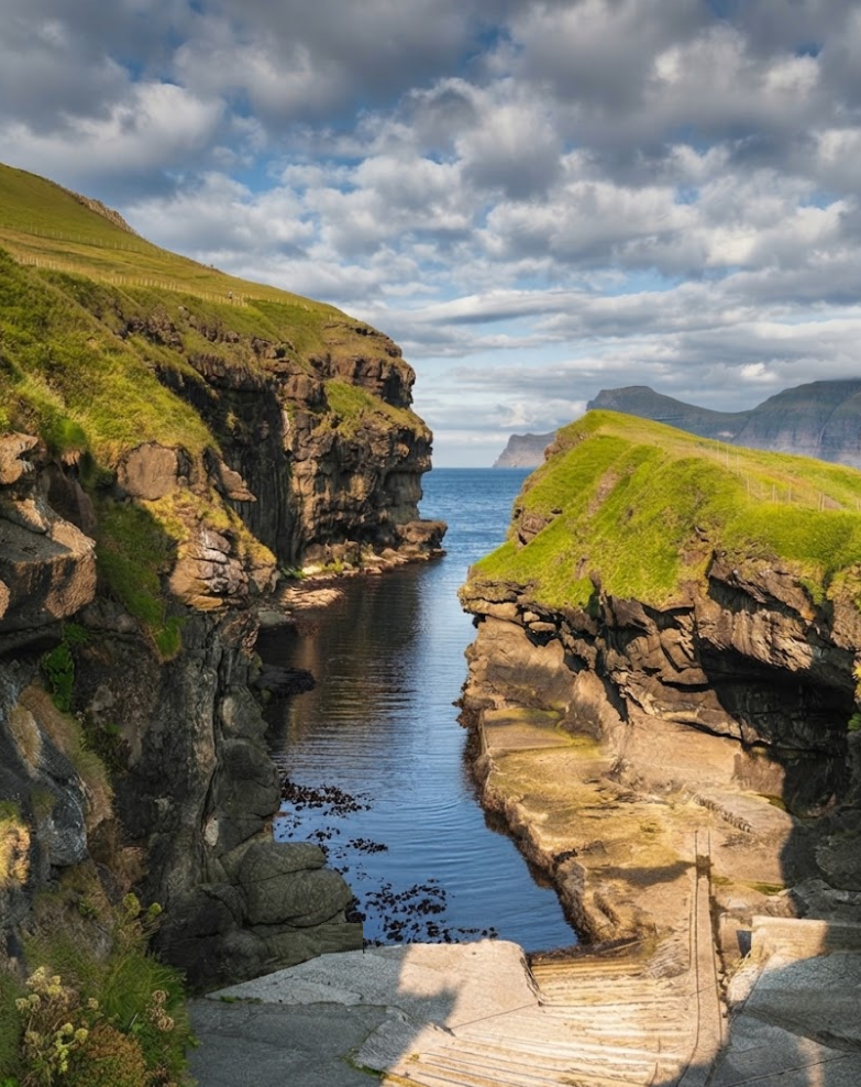
On the northern tip of Eysturoy, Gjógv sits between green slopes and basalt cliffs, a settlement shaped by sea and stone. The name itself comes from the Faroese word for gorge, and the village grew around this natural cleft in the coastline.
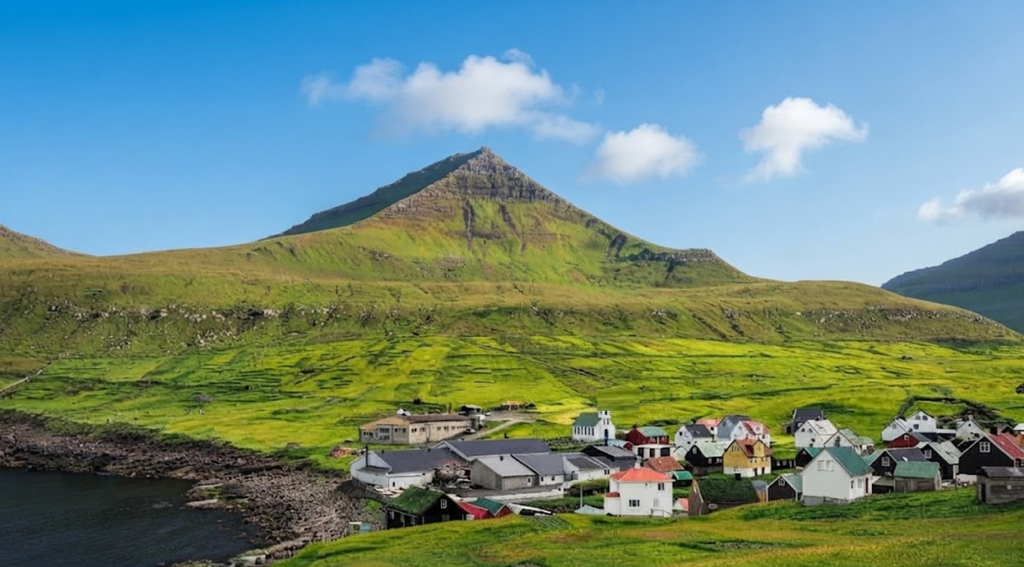
Once home to more than 200 residents and a fleet of fishing boats, today only around 50 people live here, their houses painted in red, black, white, and green, clustered around the stream that runs through the centre. Gjógv feels remote, yet paved roads, bridges, and tunnels make it surprisingly accessible.
Approaching Gjógv by Road
The journey begins at Vágar Airport, where most visitors rent a car. Public buses do reach the area, but services are infrequent, and a car offers flexibility for weather changes, luggage, and side trips. The drive is about 72 kilometres, taking 70 to 90 minutes depending on fog, sheep, or roadworks.
The route crosses Vágar, passes through the Vágatunnilin, and continues north across Streymoy before reaching the Streymin bridge into Eysturoy. From there, the road winds towards the Gjáarskarð Pass, where sharp bends and sudden fog demand slow driving. Sheep wander freely, headlights are required even in daylight, and passing places must be used carefully.
Parking is best at the entrance to the village, where a larger lot keeps narrow lanes clear. From here, visitors walk into Gjógv, crossing small bridges over the stream and passing turf‑roofed houses that blend into the slopes. The gorge itself lies just beyond, a dramatic cut in the coastline where the Atlantic surges inland.
The Gorge and Fishing Heritage
Gjógv’s gorge is more than scenery; it was once the lifeline of the community. Fishing boats entered during calm conditions, sheltered from the surf, and were pulled above the water on ramps. Boathouses and access points remain, reminders of how families lived beside the sea.
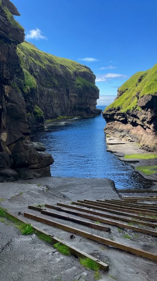
Written records date back to the 16th century, when fishing and sea transport supported the settlement long before reliable roads arrived. The layout of the village reflects this history: homes face narrow lanes, the stream, and routes leading towards the gorge.
The harbour is still in use, though on a smaller scale. Walking along the southern side of the cliff brings you to Mary’s Bench, a viewpoint overlooking the ocean. From here, the Atlantic stretches unbroken, and on clear days the outline of Kalsoy rises across the water.
Village Life Today
Gjógv remains small, with limited shops and seasonal food services. A guesthouses provide basic infrastructure, but facilities are fewer than in larger Faroese towns. Visitors should bring water, snacks, warm layers, and medicine, and check opening times before relying on local services. The atmosphere is quiet, shaped more by nature than tourism.
The stream runs through the village, crossed by small bridges, and turf roofs provide insulation against wind and rain. Other houses use corrugated roofs designed for wet conditions. Photography is welcome from public paths, but gardens and fences are private. Tripods should be kept away from narrow lanes, especially when locals are nearby.

Trails and Walks
Gjógv is also a starting point for longer walks. The Ambadalur Valley trail rises from the village towards a coastal valley, taking 60 to 90 minutes each way. The highlight is Búgvin, a 188‑metre sea stack standing offshore. The route demands supportive boots, waterproof clothing, gloves, food, and water. Fog, strong wind, or rain can remove safe visibility, and walkers should turn back when conditions deteriorate.
Another historic path leads to Funningur, about 5 kilometres away. Cairns mark higher sections. The walk takes around 80 minutes, beginning in either village, though parking is easier in Funningur. Rural buses run less often, so return transport must be planned in advance.
Combining Gjógv with Nearby Villages
Gjógv fits naturally into a road trip across northern Eysturoy. Eiði lies to the west, with views of the Risin og Kellingin sea stacks. Funningur sits south along the fjord, its houses clustered in a picturesque bay. From Gjógv, hikers can also attempt Slættaratindur, the highest peak in the Faroe Islands, though weather and visibility must be clear. Together, these villages and routes form a circuit of landscapes, heritage, and coastal views.
Driving Practicalities
Tunnel tolls are recorded by cameras rather than booths, and rental companies handle billing through packages or itemised receipts. Visitors should ask how charges appear and keep the final receipt. Reliable navigation and offline maps are essential, as fog or rain can obscure signs. Road conditions and weather cameras at Gjáarskarð help with planning. Passing places must be kept clear, and collisions with livestock must be reported to the Faroese police.
Doors should be held in strong wind, and valuables taken when leaving the car. Parking in the heart of the village is discouraged; the entrance lot is safer and less disruptive.
Weather and Light
Gjógv’s setting means weather changes quickly. Rain, fog, and wind sweep across the slopes, altering visibility within minutes. Light shifts dramatically, with cliffs and valleys appearing and disappearing in mist. On clear days, the views are expansive, stretching across the Atlantic and towards neighbouring islands. On stormy days, the gorge fills with surging water, and the village feels enclosed by mountains.

Why Gjógv Is a Hidden Gem
Gjógv is often described as a seaside village, but its enclosed setting makes it unique. Mountains close around the homes, while the gorge opens towards the Atlantic. The harbour, memorial, stream, bridges, and lanes are all close together, allowing visitors to see the main sights without rushing. Longer mountain walks begin nearby, adding variety to the visit. This mix of peace, heritage, and easy walking makes Gjógv one of the hidden gems of the Faroe Islands.
Practical Advice for Visitors
Plan at least 2 to 3 hours for the village itself, with more time for hikes. Start early, especially during shorter daylight hours. Bring supportive boots, waterproof clothing, gloves, food, and water. Carry offline navigation, as mobile signals may fade. Respect private property, keep to marked paths, and avoid nesting burrows.
A rental car is the easiest way to reach Gjógv, offering flexibility for weather and side trips. Compact cars work well on narrow roads, while families may prefer estate cars or SUVs. 4‑wheel drive helps in heavy rain, though careful driving is always required.
Takeaway
Gjógv is not a place to rush. The gorge reveals fishing history and the surrounding peaks frame the village in dramatic light. Staying longer allows visitors to experience the rhythm of weather, cliffs, and trails. It is one of the most impressive villages in the Faroe Islands, a settlement where heritage and landscape meet at the edge of the ocean.