
Calanques National Park is one of those rare places where land and sea meet in a way that feels almost otherworldly. Between Marseille and Cassis, the limestone cliffs rise starkly above the Mediterranean, their pale faces catching the light while turquoise waters shimmer below. Hiking here is not just about exercise; it is about immersion in a landscape that is both rugged and delicate, a place where hardy plants cling to cracks in the rock and secluded beaches reward those willing to walk the extra mile.

Arrival and Orientation
The journey begins with Marseille Provence Airport, the closest point of entry. From here, a 45‑minute drive delivers you to the park’s edge. While buses and metro lines can connect you to trailheads, a rental car offers freedom and flexibility, especially if you want to explore multiple calanques in a short stay. Parking, however, is limited, so early starts are essential.
Choosing a Base
Where you stay shapes your experience. Cassis is intimate, a coastal town with a harbor framed by pastel houses and a slower rhythm. It places you right at the doorstep of the most iconic hikes. Marseille, by contrast, is vibrant and sprawling, with nightlife, museums, and a metropolitan energy. Both are excellent, but Cassis offers proximity while Marseille offers variety.
Timing Your Visit
Spring and autumn are the golden seasons. April and May bring warmth without the intensity of summer, while September and October offer crisp mornings and long afternoons perfect for hiking. Summer is more complicated. Heatwaves often force trail closures to reduce fire risk, and access requires pre‑booked passes. Winter, though quieter, can be unpredictable with rain and wind.

The Signature Hike: Cassis to Calanque d’En Vau
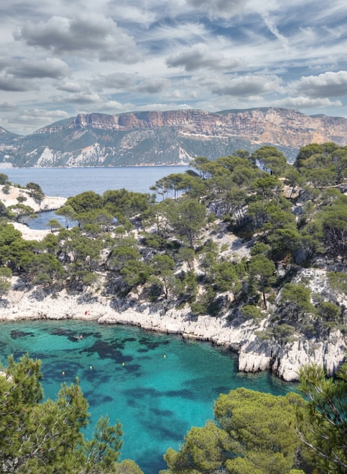
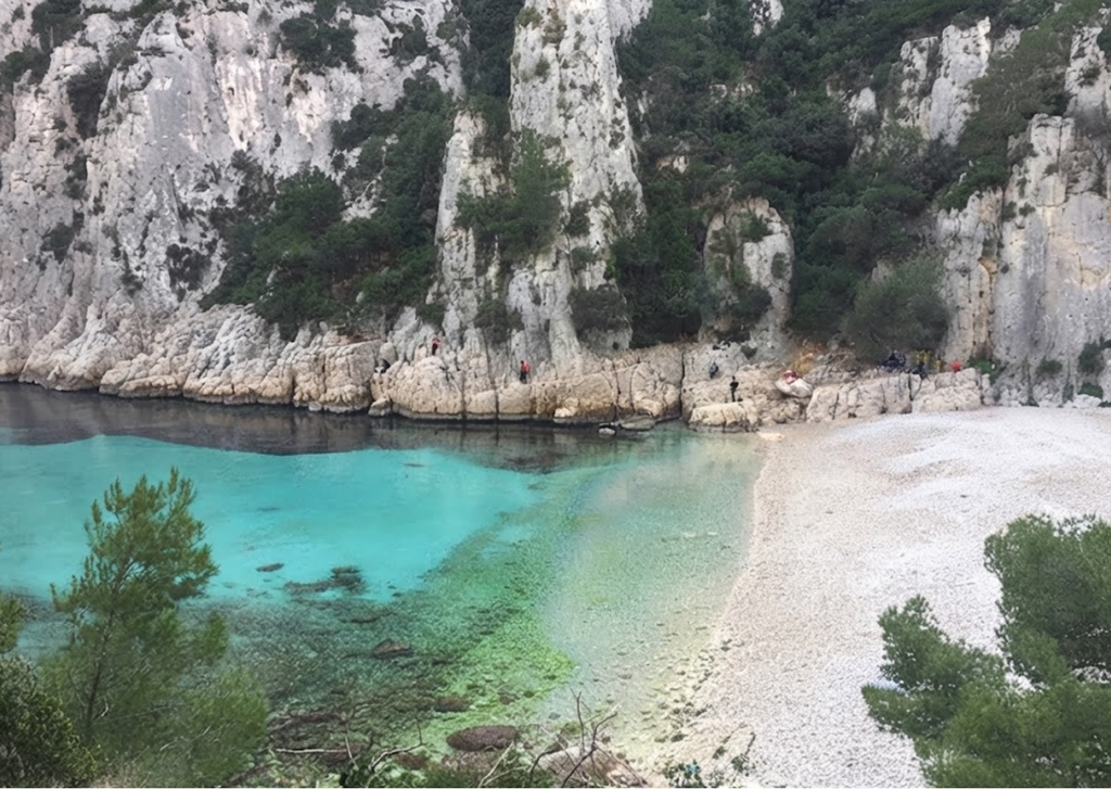
The trail from Cassis to En Vau is the park’s crown jewel. Stretching 9.3 kilometers with 400 meters of elevation gain, it is a moderate challenge that rewards at every turn. First comes Port‑Miou, a narrow inlet lined with boats, its calm waters inviting cliff jumpers. Next is Port‑Pin, a rocky beach shaded by pines, perfect for a swim. Finally, En Vau appears like a fjord, its turquoise water framed by towering cliffs. The descent is steep, the path rocky, but the sense of arrival is unmatched.
Hiking Calanque d’En Vau: Southern France’s Limestone Jewel
Calanque d’En Vau is the most dazzling of the Calanques National Park inlets, a fjord‑like canyon carved into limestone cliffs between Marseille and Cassis. With turquoise waters framed by sheer rock walls, it is accessible only by foot or boat, making the journey part of the reward.
Beginning at Port Miou
The most practical starting point is Calanque de Port Miou. A shaded dirt car park (€8 per vehicle) sits at the trailhead, though early risers can try for limited street parking nearby. From here, the path leads past the harbor’s crystalline waters before reaching Port Pin, a small cove that draws crowds by mid‑morning. Many hikers stop here, but continuing onward is essential to experience En Vau’s grandeur.
The Trail to En Vau
Marked with red and green arrows, the trail undulates across slick limestone and loose rock. It is moderate but demanding, with steep ascents and descents. At the highest ridge, the panorama evokes Bryce Canyon’s spires or Meteora’s cliffs—an otherworldly preview before dropping into the valley. The descent delivers you to En Vau’s pebble beach, where the water glows indigo thanks to underwater posidonia meadows.
Swimming and Snorkeling
The beach is small and often crowded, but snorkeling quickly carries you beyond the bustle. Expect cool water and occasional jellyfish. Water shoes are vital—the pebbles are sharp, and newcomers often tiptoe across them in comic discomfort.
Scenic Return Path
After swimming, return via the blue coastal trail. Though longer, it hugs the cliffs and offers sweeping Mediterranean panoramas with far fewer hikers. The loop brings you back to Port Pin, perfect for a second dip and a picnic of baguettes and croissants.

Practical Essentials
Bring ample water—there are no concessions or fountains. Sun protection is critical, as shade is scarce. Camping is forbidden, but climbers flock to En Vau’s vertical walls. Park access is regulated in summer due to fire risk; check the Mes Calanques app or the Bouches‑du‑Rhône website for daily updates.
Geological Story
En Vau’s canyon was carved by ancient erosion and tectonic shifts, its valley narrowing as it approaches the sea. The result is a dramatic limestone corridor that feels like the end of the world.
Why It Matters
En Vau is not just a hike; it is immersion in geology and sea. Passing through Port Miou, Port Pin, and finally En Vau, the trail reveals the calanques in their full splendor. Whether approached on foot or glimpsed from a kayak, Calanque d’En Vau is the most spectacular of the 26 calanques—a place where cliffs, sea, and sky converge in unforgettable harmony.
The Scenic Route: Calanque de Sugiton

Sugiton is a favorite for its views. The 8‑kilometer trail is gentler, with wide paths leading to twin coves ideal for swimming. The Belvédère de Sugiton viewpoint offers sweeping vistas over Morgiou, while a hidden ladder climb reveals another lookout few visitors find. The descent is gradual, the return manageable, making it one of the most rewarding yet accessible hikes in the park.
Hiking to Calanque de Sugiton – A Complete Guide
The Calanques National Park stretches along the Mediterranean coast south of Marseille, a rugged landscape of limestone cliffs, pine forests, and hidden coves. Among its many trails, the hike to Calanque de Sugiton stands out as one of the most accessible and rewarding. Compact in length yet rich in scenery, it offers a blend of gentle walking, steep descents, and the thrill of reaching turquoise waters framed by towering cliffs.
Approaches to the Calanques
The park can be entered from several points. To the west, Les Goudes serves as the gateway to Calanque de Marseilleveyre and Calanque de Podestat. To the east, Cassis is the traditional starting point for the famous trio of Port Miou, Port Pin, and Calanque d’En Vau. In the central section, Marseille’s southern suburbs provide access to Calanque de Sormiou, Calanque de Morgiou, and Calanque de Sugiton. The Luminy university area is the most practical launch point for Sugiton, and it is here that most hikers begin their journey.
Essential Hiking Information
The trail to Sugiton is approximately six to seven kilometres return, with a duration of two and a half to three hours depending on how much time you spend at the coves. The difficulty is rated easy to moderate. The first section is flat and straightforward, but the descent to the water is steep and rocky, and the return is uphill all the way.
The best seasons are spring and autumn, when temperatures are mild and the risk of fire closures is lower. Winter hikes are perfectly enjoyable on calm days, though strong winds can make conditions hazardous. From mid-June to mid-September, access is regulated, and reservations are required. Entry remains free, but numbers are capped to protect the fragile environment.
Dogs are permitted, making this one of the more family-friendly calanques. Still, the steep descent requires caution if hiking with children or pets.
Getting There – Car or Bus
Driving through Marseille can be daunting, with heavy traffic even on weekends. A useful alternative is to bypass the city via Aubagne. Parking is available near the Luminy campus, either in surrounding streets or in the gravel car park by the Business School. On busy days, cars line both verges, though this is not recommended.

Public transport is straightforward. The 21 bus from Castellane station on Avenue du Prado runs directly to Luminy, dropping passengers close to the trailhead. The B1 bus also serves the route, stopping at Luminy PN des Calanques. For visitors without a car, this is one of the easiest calanques to reach.
The Blue Route – A Gentle Beginning
The hike begins on the Blue Route, a wide track that winds gently through pine forest. The first thirty minutes are uneventful but pleasant, a chance to settle into the rhythm of walking. The air carries the fragrance of wild herbs, and occasional breaks in the trees reveal glimpses of limestone cliffs.
After half an hour, the path reaches the Col de Sugiton, a broad esplanade where trails diverge. Here you can continue toward the calanque or detour to the Belvedere de Sugiton.
The Belvedere – A Panoramic Detour
The Belvedere is a short climb, about one kilometre round trip, but the views are spectacular. From its platform, you can see both Sugiton and Morgiou, their coves framed by cliffs and the islands of Marseille scattered across the horizon. The panorama is one of the finest in the park, and many hikers consider it the highlight of the walk.
If time allows, the Belvedere is worth the detour. It adds only half an hour to the hike but transforms the experience into something more expansive.
Choosing Your Descent
From the Col, two main routes lead down to the sea. The first is the DFCI track, a winding service road used by fire engines. It is longer but easier, with a gradual slope. The second is the red-dotted path, shorter but steeper, strewn with rocks and stairs. Both converge near the water, and many hikers choose one route down and the other back up.
The descent is accompanied by dramatic scenery. Limestone cliffs rise on either side, ancient stone walls line the path, and the sea appears intermittently through gaps in the vegetation. The fragrance of thyme and rosemary drifts on the breeze, a reminder that this is Provence.
Arrival at the Calanque
The final approach reveals the calanque in full. The cliffs open, and turquoise water glimmers below. The main beach of Sugiton is closed due to rockfall risk, but two smaller coves remain accessible. These are reached by narrow paths branching off the main track.
In summer, the coves fill quickly, with bathers spreading onto the surrounding rocks. In winter, they are often deserted, offering solitude and silence. The seabed is rocky, so water shoes are useful. Swimming here feels wild and invigorating, the cliffs rising sheer above the water.
The Return Journey
The climb back is uphill throughout. The red-dotted path offers a quicker but more strenuous ascent, cutting across the bends of the DFCI track. The final stretch along the Blue Route feels like a relief, a gentle walk after the exertion of climbing.
Practical Advice
Carry at least one to one and a half litres of water per person. Snacks are useful if you plan to linger at the coves. Hiking shoes are essential, and water shoes make swimming easier. A swimsuit and towel are obvious additions.
Start early to avoid the midday heat and to secure space at the coves. There are no facilities nearby, so bring everything you need.
Extending the Hike
For those with energy, the hike can be extended. From the Belvedere, trails lead toward Morgiou, allowing a half-day circuit that combines two calanques. The Grande Candelle, a towering limestone peak, dominates the landscape here. Climbers come from far and wide to tackle its dihedrals and overhangs, and the panorama from its walls is sublime.
Why Sugiton Stands Out
Sugiton is smaller than some of the other calanques, but its charm lies in its intimacy. The cliffs are dramatic, the water vivid, and the approach varied enough to feel like a real hike. It balances accessibility with beauty, making it ideal for families, casual walkers, and those seeking a manageable adventure.
The Belvedere adds grandeur, the coves add relaxation, and the climb ensures a sense of achievement. Together, they create one of the most rewarding short hikes in Provence.
Seasonal Atmosphere
In spring, the trail is alive with wildflowers, and the air is fresh. Autumn brings softer light and quieter paths. Winter offers solitude, with the sea often rough and dramatic. Summer is busy, regulated, and hot, but the water is irresistible. Each season has its character, and Sugiton adapts to them all.
The Quiet Escape: Calanque de Marseilleveyre
For solitude, Marseilleveyre is unmatched. Starting from Callelongue, the 8.2‑kilometer loop climbs into the park before dropping into the Malvalon Valley. The beach here is small, a mix of sand and pebbles, with views of the Riou Archipelago stretching across the horizon. Unlike En Vau or Port‑Pin, Marseilleveyre feels remote, a place where the crowds thin and the silence deepens.
Family‑Friendly Adventure: Calanque de Sormiou
Closer to Marseille, Sormiou is accessible yet enchanting. The 2‑kilometer trail takes about an hour each way, manageable for families with older children. The sandy beach is lifeguarded in summer, and cabins dot the shoreline, giving it a lived‑in feel. The climb back is steep and exposed, so water and sun protection are essential. Public transit makes it easy to reach, with bus 22 connecting from the metro at Rond Point de Pano.
Gentle Exploration: Port Miou and Port Pin
For those with limited time or younger children, the 2‑kilometer trail from Port Miou to Port Pin is ideal. Shaded by pines, the path is mostly flat until the final descent into Port Pin’s pebble beach. It takes about 45 minutes each way, and the scenery is no less impressive than the longer hikes. Parking at Port Miou is straightforward, though fees apply in high season.
Beyond Hiking
The Calanques are not only for walkers. Renting a boat in Cassis allows you to glide past cliffs and coves, with Sugiton a highlight from the water. Kayaking and paddleboarding bring you closer to the shoreline, while scuba diving reveals marine life beneath the surface. Rock climbing is popular too, with limestone walls offering routes for all levels. For those who prefer to relax, sunbathing and swimming in the coves are pleasures in themselves.
Practical Preparation
The park’s terrain demands respect. Shade is scarce, so hats, sunscreen, and abundant water are non‑negotiable. Sturdy shoes are essential; flip‑flops will not suffice on rocky paths. Maps provide reassurance, though trails are generally well marked. Hiking early or late avoids the harshest sun and secures parking. Between June and September, closures are common, so checking official updates is critical.
The Landscape’s Character
Calanques National Park is unique in Europe, combining marine, land, and semi‑urban zones. Soil is scarce, and vegetation is sparse, with hardy plants pushing through cracks in limestone. The cliffs are stark, the water crystalline, and the contrast between the two defines the park’s identity. It is a place of resilience and beauty, where nature thrives in unlikely conditions.
A Three‑Day Rhythm
Three days allow a balanced experience. Day one might begin with the Cassis to En Vau hike, followed by an evening in Cassis harbor. Day two could focus on Sugiton and a boat trip, blending hiking with time on the water. Day three might explore Marseilleveyre or Sormiou, offering variety and depth. Each day brings a different perspective, from iconic vistas to quiet coves.
The Magic of Arrival by Foot
What makes the Calanques special is the effort required. Beaches here are not reached by roads or resorts but by trails. The act of walking, of climbing and descending, makes the arrival more meaningful. Standing at En Vau after a rocky hike, or swimming at Sugiton after a gentle descent, carries a sense of discovery. It is this blend of challenge and reward that defines the park.
Final Impressions
Calanques National Park is not vast, but it is mighty. Its cliffs and coves, its trails and waters, create a landscape that feels both intimate and grand. Whether you hike to En Vau, swim at Sugiton, or sail past Marseilleveyre, the experience is unforgettable. It is a place where preparation meets spontaneity, where effort meets reward, and where the Mediterranean reveals one of its most extraordinary secrets.